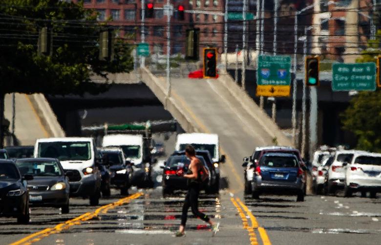
It’s a forecast so hot that it left some seasoned meteorologists initially in disbelief.
Weekend temperatures are expected to approach 100 degrees in Seattle, top 109 in Portland and reach 115 in Eastern Washington — threatening to topple historical records and upend people’s lives.
“Is this just the models being wonky, or is this a real deal?” said Joe Boomgard-Zagrodnik, a postdoctoral researcher in agricultural meteorology at Washington State University, describing his reaction to initial temperature readouts.
When he assessed the data himself, “it was jaw-dropping.”
Climate scientists and meteorologists say the forthcoming heat wave — which could persist into next week — is a manifestation of climate change and a concerning signal of what they expect more frequently in the Pacific Northwest, which is poorly adapted to extreme heat.
“This is pretty early in the season to be experiencing so many days where temperatures are record breaking. It’s worrisome. It’s just June,” said Deepti Singh, a climate scientist and assistant professor at WSU Vancouver. “This should be a warning sign for us that we’re experiencing the impacts of climate change right now.”
The science of heat
The weather pattern bringing scorching hot temperatures to the Northwest is the result of a large ridge of high atmospheric pressure sometimes called a heat dome.
AdvertisingHigh pressure systems suppress storms, offering clear skies with full sun, and they act as a cap and trap heat near the surface.
“Air is sinking and it’s warming as it sinks,” Boomgard-Zagrodnik said.
This weather pattern itself is extreme, but not unprecedented, said Nick Bond, an atmospheric scientist at the University of Washington who also serves as the state’s climatologist. He does not predict that patterns of pressure will change in the coming decades, though he acknowledges that research is still developing.
What has changed is that the region has warmed nearly 2 degrees since 1900, according to the 2018 national climate assessment by U.S. Global Change Research Program, crafted with input from 13 federal agencies.
“Now, when you have heat waves, when that baseline has moved up … it’s that much more severe,” Bond said.
Heat waves are projected to increase in frequency and intensity across the country, according to the climate assessment.
AdvertisingResearchers say Seattle and other areas of the Pacific Northwest are poorly adapted to extreme heat. Residents are not physically acclimated to heat and fewer than half have home air conditioning, one of the lowest rates among big U.S. cities.
And nighttime temperatures, which often provided a respite on hot Seattle days, are less reliably comfortable. In the Northwest, overnight low temperatures are actually warming more rapidly than daytime temperatures.

In the Puget Sound region, average minimum temperatures have climbed between 3 and 4 degrees, Bond said.
Because this weekend’s bout with scorching temperatures follows relatively recent rain, Boomgard-Zagrodnik said he expected little relief at night.
“It’s going to be pretty bad, probably, because of the high humidity” and light evening winds, Boomgard-Zagrodnik said, adding that he would be surprised if overnight temperatures dropped below 70 degrees.
Respites from the heat
The heat wave could have profound effects on Washington state.
Advertising“Hospitals in past heat events have seen marked increases in heat stroke, heart attacks and kidney failure,” said Addison Houston, an environmental health mitigation & response planner with Public Health Seattle & King County, citing an analysis of emergency calls in King County.
Vulnerable people, such as children, older adults and people with underlying health conditions, need access to cooling during heat waves, said Singh, the WSU climate scientist.
Seattle is offering at least 13 air-conditioned public library branches, 10 wading pools, nine spray parks and eight lifeguarded beaches as spots to cool down.
Most Read Local Stories
“Often I hear: Go to the coast or go to the Cascades,” Singh said. ”If you’re well off, sure, that’s an option, but that’s not an option for everybody.”
Air quality could worsen, Singh said, because heat and sunlight can intensify chemical reactions that create surface-level ozone, which can inflame the respiratory system.
Any power outages would exacerbatedifficulties for those who lose electricity for fans or air conditioning, but utility officials in the Pacific Northwest say that’s unlikely to happen.
Sponsored
Officials at the Bonneville Power Administration, which operates the regional transmission system that delivers much of the electricity to regional utilities, say they should be able to get through the peak heat days without service interruptions.
The Portland-based BPA has benefitted from the return to service of the Columbia Generation Station, a nuclear power plant outside of Richland that is the third-largest generator of electricity in the region and had been down for more than 40 days for refueling.
The hydroelectric dams along the Columbia River, which collectively represent the largest source of the region’s power, have shifted from spring to summer operations, which reduces spill for fish and enables more overall power generation.
“At this time, we thoroughly expect to be able to meet the load demands of our customers,” said Kevin Wingert, a BPA spokesman.
Seattle City Light, which owns hydroelectric dams that provide about half of its power, also appears in good shape.
“We expect to be able to meet projected demand with the high temps forecasted for this weekend and are not anticipating impacts to the grid,” said Julie Moore, a Seattle City Light spokesperson.
AdvertisingPuget Sound Energy’s system is “currently performing well,” and the utility plans to meet all demand with its own generation assets, according to Janet Kim, a company spokesperson.
Still, utility officials say conservation always is encouraged and can include opening windows at night to allow cooler air in, limiting use of appliances that generate heat and turning off ceiling fans when you leave a room.
Extreme heat also increases the potential of wildfires and smoke.
Unlike other parts of the Western U.S., Washington’s mountain ranges built a hearty snowpack over winter.
“There’s still a fair amount of snow above 5,000 feet,” Bond said. But at lower elevations, mixed grasslands on the east flank of the Cascades are “ready to go” and catch fire, he added.
The high pressure system is expected to quell winds when temperatures are peaking, which reduces the chances of runaway fires, but also cuts back on power generation by wind turbines that are an increasingly important part of the region’s energy mix.
AdvertisingNext week, as the heat wave eases, winds are expected to pick up and fire dangers will increase, with the landscape baked in heat.
With the robust snowpack, irrigators on the big river systems, such as the Columbia and Yakima, should have sufficient water for orchards and vineyards, Bond said. But portions of Washington remain in a drought, which is particularly severe in the southeastern corner of the state. Crops that often are not irrigated, like wheat and barley, already are suffering.
Bond said climate models are at consensus that the remaining summer months will be warmer than average. He expects stream temperatures on some of the state’s smaller rivers to become “dangerously warm” for salmon and trout later in the summer.
Disparate impacts
The forthcoming heat event won’t be felt evenly.
Boomgard-Zagrodnik expects the broad heat dome to suppress large-scale wind patterns, such as the onshore flow typical to the region. But with Puget Sound waters still relatively cool, local winds and geography could create huge differences in how people feel over the weekend.
“Islands and uneven coastlines — the topography and where you’re located relative to the water is going to make a big difference in whether you’ll have the chance to get up to 95, 100 or more, or whether you’ll get a nice breeze in the afternoon,” he said.
Whidbey Island and the San Juans are likely to pick up a sea breeze, whereas areas south of Seattle, like Olympia, will be shielded from the cooling flow.
AdvertisingIn Portland, the National Weather Service forecasts temperatures rising to 104 degrees on Saturday, reaching 109 on Sunday before easing back to 104 on Monday.
This early summer heat, if it reached those levels, would blow away records for three consecutive days. Portland’s all-time high is 107, reached twice in August 1981 and once in July 1965. The record for June is 102.
In urban areas, heat does not affect everyone equally. Analysis of temperature records in King County on a hot day last July showed heat impacts varied widely in communities mere miles apart. Trees mitigated heat while industry and dense buildings intensified it.
Communities affected by other environmental health concerns, such as poverty and pollution, are among the hottest communities, the mapping suggests.
Scientists for decades have warned that our reliance on fossil fuels is warming our world. Now, they say, we’re taking the heat.
Evan Bush: 206-464-2253 or ebush@seattletimes.com; on Twitter: @EvanBush. Hal Bernton: 206-464-2581 or hbernton@seattletimes.com; on Twitter: @hbernton.


